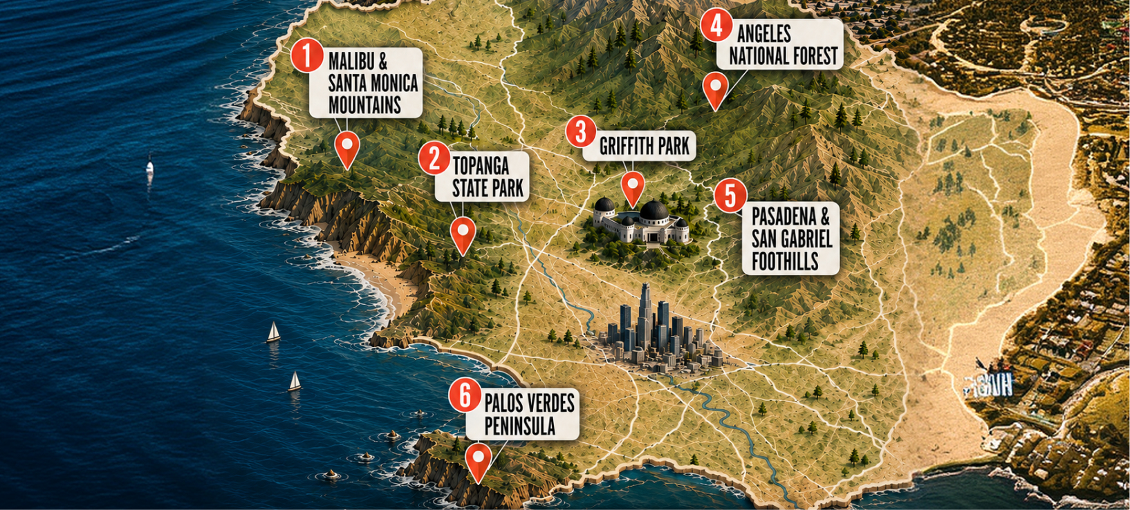
From dramatic oceanfront cliffs and hidden waterfalls to iconic Hollywood views and alpine mountain summits, Los Angeles offers incredible outdoor diversity across its coastal and mountain ecosystems.
Here is your comprehensive guide to the 6 essential hiking regions in LA County, including precise trailhead starting points, logistics, and regional highlights.
1. Malibu & The Santa Monica Mountains
- Vibe: Coastal views, shaded canyons, seasonal waterfalls, and coastal sage scrub.
- Best Time to Hike: Year-round (mornings preferred in summer; late winter for active waterfalls).
Top Hikes
Point Dume Cove Trail
- Best Trailhead: Point Dume Nature Preserve Trailhead (Cliffside Dr & Birdview Ave)
- Distance / Structure: ~1.4 miles (Loop)
- Difficulty: Easy
- Key Highlights: Bluffs overlooking the Pacific, seasonal gray whale watching (Dec–April), sea lion sightings.
- Logistics: Check Point Dume parking status before heading out, as the small paid lot at the trailhead fills rapidly. Limited street parking on Cliffside Drive.
Solstice Canyon Loop
- Best Trailhead: Solstice Canyon Main Parking Lot Trailhead (Corral Canyon Rd & Solstice Canyon Rd)
- Distance / Structure: ~3.0 miles (Loop)
- Difficulty: Easy to Moderate
- Key Highlights: Shaded stream paths along top Santa Monica Mountains waterfall trails, architectural ruins of the Roberts Ranch house, seasonal waterfall.
- Logistics: Free parking lot at the trailhead (fills quickly on weekends). Dog-friendly on leash.
Escondido Falls Trail
- Best Trailhead: Edward Albert Escondido Canyon Trailhead (Winding Way off PCH)
- Distance / Structure: ~3.8 miles (Out-and-Back)
- Difficulty: Moderate
- Key Highlights: Multi-tiered waterfall (best active after rain), lush canyon scenery along prime Malibu coastal hikes.
- Logistics: Paid parking lot off Winding Way / PCH. First mile follows a paved road before reaching the dirt trailhead.
2. Topanga State Park
- Vibe: Massive urban wilderness featuring sandstone outcrops, oak woodlands, and wide ocean-to-city panoramas.
- Best Time to Hike: Fall through Spring.
Top Hikes
Los Liones Trail to Parker Mesa Overlook
- Best Trailhead: Los Liones Drive Trailhead (End of Los Liones Dr off Sunset Blvd)
- Distance / Structure: ~7.3 miles (Out-and-Back)
- Difficulty: Moderate to Strenuous
- Key Highlights: Continuous ascent through lush chaparral leading to a sweeping panoramic view of Santa Monica Bay.
- Logistics: Check Los Liones Trail parking availability early; free street parking runs along Los Liones Drive. Very popular, so start before 8:00 AM on weekends.
Eagle Rock via Musch Trail
- Best Trailhead: Trippet Ranch Main Trailhead (Entrada Rd)
- Distance / Structure: ~4.5 miles (Loop)
- Difficulty: Moderate
- Key Highlights: Unique hollowed sandstone formations, spring wildflowers, and cooling ocean breezes that make it a favorite among Topanga State Park view hikes.
- Logistics: Always check Parker Mesa Overlook trail conditions and general park bulletins before visiting. Park at Trippet Ranch (State Park vehicle fee applies). Clean restrooms and water stations available at the trailhead.
Griffith Park
- Vibe: Classic Los Angeles landmarks, skyline views, chaparral ridges, and high urban accessibility.
- Best Time to Hike: Year-round (Golden hour / Sunset recommended for city lights).
Top Hikes
Mount Hollywood Trail
- Best Trailhead: Charlie Turner Trailhead (Behind Griffith Observatory Parking Lot)
- Distance / Structure: ~3.0 miles (Out-and-Back)
- Difficulty: Easy to Moderate
- Key Highlights: 360-degree views of Downtown LA, the Hollywood Sign, and the Griffith Observatory across core Griffith Park trails.
- Logistics: Starts behind the Griffith Observatory. Paid parking in the Observatory lot, or free lower lot parking (requires extra uphill walk).
Brush Canyon Trail to the Hollywood Sign
- Best Trailhead: Brush Canyon Trailhead (End of Canyon Dr)
- Distance / Structure: ~6.4 miles (Out-and-Back)
- Difficulty: Moderate
- Key Highlights: Prominent choice for Hollywood Sign hikes that takes you directly behind the iconic landmark on Mount Lee.
- Logistics: Trailhead located at the end of Canyon Drive. Dedicated dirt parking lots available.
West Observatory Loop
- Best Trailhead: Fern Dell Picnic Area Trailhead (Fern Dell Dr & Black Oak Dr)
- Distance / Structure: ~2.1 miles (Loop)
- Difficulty: Moderate
- Key Highlights: Quick, rewarding workout featuring a clear West Observatory Loop map layout leading directly up to the Observatory grounds.
- Logistics: Park near Fern Dell Drive (shaded picnic area nearby).
4. Angeles National Forest
- Vibe: True high-altitude alpine terrain, rugged granite peaks, river crossings, and backcountry wilderness.
- Best Time to Hike: Late Spring to Fall (check snow levels in winter).
Top Hikes
Mount Baldy via Baldy Bowl Trail
- Best Trailhead: Manker Campground Trailhead (Mt Baldy Rd)
- Distance / Structure: ~9.4 miles (Loop)
- Difficulty: Strenuous / Expert
- Key Highlights: Highest point in LA County (10,064 ft elevation), steep alpine ridge-walking, extreme summit views. Always monitor Mount Baldy current snow conditions before attempting in winter or spring.
- Logistics: Requires an Angeles National Forest Adventure Pass for parking. High altitude and steep exposure; proper gear and hydration are essential.
Bridge to Nowhere
- Best Trailhead: Heaton Flats Trailhead (End of Camp Bonita Rd off San Gabriel Canyon Rd)
- Distance / Structure: ~10.0 miles (Out-and-Back)
- Difficulty: Strenuous
- Key Highlights: Multiple wet river crossings along the San Gabriel River leading to an abandoned 1930s concrete bridge.
- Logistics: Adventure Pass required at Heaton Flats trailhead. A Bridge to Nowhere permit is required for entry.
Switzer Falls
- Best Trailhead: Switzer Picnic Area Trailhead (Angeles Crest Hwy / CA-2)
- Distance / Structure: ~3.7 miles (Out-and-Back)
- Difficulty: Moderate
- Key Highlights: Shaded stream canyon, historic resort ruins, and a popular waterfall plunge pool.
- Logistics: Adventure Pass required for Switzer Picnic Area parking.
5. Pasadena & San Gabriel Foothills
- Vibe: Historic mountain ruins, shaded streams, accessible foothill slopes, and seasonal waterfalls.
- Best Time to Hike: Winter, Spring, and early mornings in Summer.
Top Hikes
Eaton Canyon Falls
- Best Trailhead: Eaton Canyon Nature Center Trailhead (Altadena Dr)
- Distance / Structure: ~3.5 miles (Out-and-Back)
- Difficulty: Easy
- Key Highlights: Family-friendly flat dirt path leading to a 40-foot waterfall. Check Eaton Canyon trail updates after heavy rains.
- Logistics: Large free lot at Eaton Canyon Nature Center. Highly frequented on weekends.
Echo Mountain via Sam Merrill Trail
- Best Trailhead: Sam Merrill Trailhead (Top of Lake Ave & E Loma Alta Dr)
- Distance / Structure: ~5.4 miles (Out-and-Back)
- Difficulty: Moderate to Strenuous
- Key Highlights: Constant switchbacks on a classic Echo Mountain historic ruins hike leading to the remains of the 1890s Mount Lowe Railway and resort.
- Logistics: Trailhead at the top of Lake Avenue in Altadena. Street parking available in residential zones.
Brown Mountain Dam via JPL
- Best Trailhead: Gabrielino Trailhead at JPL (Windsor Ave & Explorer Rd)
- Distance / Structure: ~5.1 miles (Out-and-Back)
- Difficulty: Moderate
- Key Highlights: Arroyo Seco stream crossings, oak canopy, ending at a historic 1920s dam structure along the Brown Mountain Dam JPL route.
- Logistics: Park near the NASA Jet Propulsion Laboratory (JPL) parking structures.
6. Palos Verdes Peninsula
- Vibe: Dramatic coastal bluffs, steep ocean drop-offs, sea caves, tide pools, and views of Santa Catalina Island.
- Best Time to Hike: Year-round (Marine layer / coastal fog often clears by mid-day).
Top Hikes
Ocean Trails Reserve
- Best Trailhead: Ocean Trails Reserve Trailhead (Trump National Dr)
- Distance / Structure: ~2.5 to 4.0 miles (Network of Trails)
- Difficulty: Easy to Moderate
- Key Highlights: Expansive coastal bluff walks directly above the Pacific with ocean access points mapped out across the Ocean Trails Reserve map.
- Logistics: Public trail parking available near Trump National Golf Club lot.
- Alta Vicente Trail
- Best Trailhead: Alta Vicente Reserve Trailhead (Hawthorne Blvd & Vallon Dr)
- Distance / Structure: ~1.3 miles (Out-and-Back / Connector)
- Difficulty: Easy
- Key Highlights: Restored coastal sage scrub habitat, view of the Point Vicente Lighthouse.
- Logistics: Street parking along Hawthorne Blvd or nearby park areas.
Abalone Cove Bluff Trail
- Best Trailhead: Abalone Cove Shoreline Park Trailhead (Palos Verdes Dr S)
- Distance / Structure: ~1.0 mile (Out-and-Back)
- Difficulty: Moderate (steep descent/ascent)
- Key Highlights: Direct access to rocky coves, sea caves, and vibrant Abalone Cove tide pools.
- Logistics: Always review Palos Verdes trail closures land movement updates before setting out. Paid parking lot at Abalone Cove Shoreline Park. Check tide charts before heading down to the shoreline.
How to Connect & Organize Hikes in Los Angeles
Want to Find Hiking Groups & Events Near You?
- Head to the Events Tab: Open SportyMatch or visit the website and go to the Events section.
- Filter by Location & Sport: Set your location to Los Angeles and select Hiking to find local hikes, walking groups, weekend outings, and outdoor meetups.
- Join Other Local Hikers: Find people planning hikes around Griffith Park, Malibu, Topanga, the Santa Monica Mountains, and other parts of Los Angeles, then RSVP to join.
Want to Organize Your Own Hike?
- Tap Create Event: Start a new event in SportyMatch.
- Select Hiking: Choose Hiking as the activity.
- Add the Meeting Location: Pin the trailhead or another clear meeting point.
- Name the Hike: Use a simple title such as Sandstone Peak Saturday Morning Hike.
- Set the Time: Add the date and meeting time.
- Invite Other Hikers: Invite friends or other local hikers to join.
Essential Trail Safety Checkpoints
Before heading out on any trail in Southern California, always verify real-time conditions:
- Land Movement & Slide Closures: Sections of coastal areas (especially in Palos Verdes and parts of Malibu) may experience temporary closures due to geological activity or rain-induced erosion.
- Fire Restrictions & Air Quality: Check the National Weather Service for Red Flag warnings and AQMD for regional air quality readings during dry months.
- Parking Permits: Ensure you possess an USFS Adventure Pass when parking in designated areas within the Angeles National Forest.